 ABOUT ENVI
12/10/2018
ABOUT ENVI
12/10/2018
ENVI image analysis software is used by GIS professionals, remote sensing scientists, and image analysts to extract meaningful information from imagery to make better decisions. ENVI can be deployed and…Read more
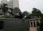
 Digicom completed the project of satellite communication vehicle
07/12/2016
Digicom completed the project of satellite communication vehicle
07/12/2016
After finishing the intergration of satellite communication vehicle, Digicom got the highly appreciation from customer about service quality. These are some photos in the deployment: Pre – installation works. Equipments…Read more
 Project on satellite HUB, Flayaway, satellite communication vehicle installation
07/12/2016
Project on satellite HUB, Flayaway, satellite communication vehicle installation
07/12/2016
Digicom deployed the project on satellite HUB, Flyaway terminals and satellite communication vehicle installation for our local customer. They highly appreciate the system quality in operation. Some Photos in the…Read more